


Everyone knows about the beautiful cliffs that drop hundreds of feet into Lake Superior in Pictured Rocks National Lakeshore. Everyone also knows these cliffs are multi-hued and extremely photogenic. The park is so well known for this phenomenon that they had the wherewithal to name the park after them.

Grand Portal Point in Pictured Rocks
Pictured Rocks is more than a lakeshore
I was also aware that since the park lies on the coast of Lake Superior that there would be many miles of beautiful shoreline. The lakeshore and beautiful cliffs did not come as a surprise when I hiked 42 miles on the North Country Scenic Trail through the park over Columbus Day weekend. However, many facets of this park surprised me.
Grand Sable Dunes in Pictured Rocks National Lakeshore
Sleeping Bear Dunes like dunes
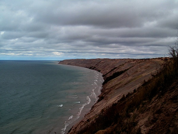
When I drove the scenic H58 route to Au Sable to start my hike, I noticed dunes along the side of the road. I did not know Pictured Rocks had dunes. When I hiked the first 5.8 miles to Logslide, it shocked me to not only find dunes, but epic ones.

Looking down a couple hundred feet to Lake Superior at Logslide on the Grand Sable Dunes
The Grand Sable Dunes found at Logslide that stretch along the shoreline to the east were as beautiful and impressive as any found in Sleeping Bear Dunes. I came to the scenic overlook and my mouth was agape at the sight before me and below me. The dunes dive straight down 300 feet to Lake Superior.
Au Sable Light Station
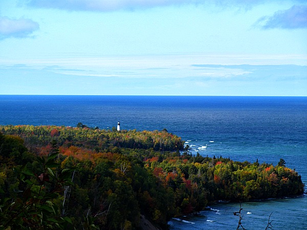
In case 300 foot sand dunes along Lake Superior do not impress you, to the west at Logslide, the Au Sable Light Station comes into view. The view of the lighthouse sticking out on a piece of land covered with colorful trees is something one would expect to find in Maine.
Au Sable Light Station from the Logslide in Pictured Rocks
The lighthouse is 2 miles away from Logslide. The hike here provides several perfect photo opportunities to capture the lighthouse from both near and far. This is also a great vantage point to view the dunes from far off.

Au Sable Light Station in Pictured Rocks
Beaches
I figured the hike would be primarily along cliffs overlooking Lake Superior. Not only did I find dunes, but also many miles of remote beaches. A plethora of beautiful beaches highlight the central section of the trail in the national lakeshore. Once the cliffs begin, they dominate the shoreline; however a few beaches make an appearance in between the cliffs in the western section of the park. This makes the park a desirable place to hike in the summer as well. One could easily find their private stretch of beach and enjoy a cool down in the lake.

Pictured Rocks features miles of beautiful pristine Lake Superior beaches
Walk in the woods
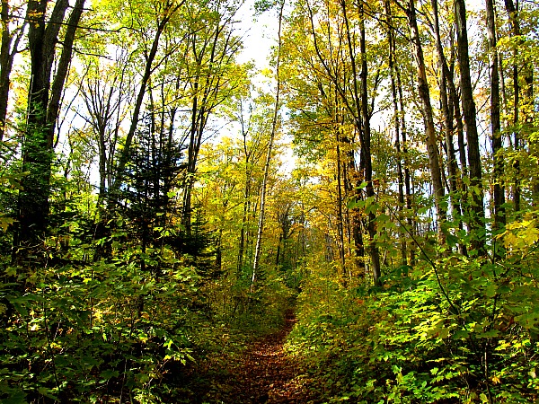
Although the North Country Trail is referred to in the park as the Lakeshore Trail, many stretches of the trail dart through the woods. A mixture of coniferous and hardwoods line the trail with sometimes being primarily one or the other. This provides a wonderful change in case you get tired of mouth dropping views of Lake Superior. You can only take so much of those before your bones in your face get sore.
Beautiful fall colors in a Pictured Rocks forest
Streams and lakes
It is not a big shock that many streams and rivers run through a park along Lake Superior. Just about every stream and river in the territory head towards Lake Superior. Hiking 42 miles along the coast, it is not unusual to have to cross several of these creeks. One of these creeks, Spray Creek, creates a beautiful waterfall tumbling over the cliffs into Superior. This waterfall is so beautiful, it deserves its own post.
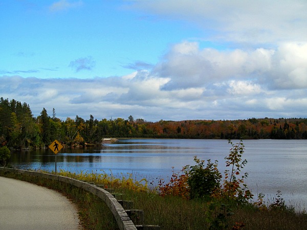
Grand Sable Lake
Related: Pictured Rocks Spray Falls photos
The trail begins near Grand Sable Lake. The North Country Trail wraps around the northern portion of the lake with great views including a hike through the scenic view parking lot. Kingston Lake, Beaver Lake, and Trappers Lake round out the beautiful Pictured Rocks inland lakes.
The North Country Trail through Pictured Rocks is incredibly diverse
Every three or four miles, something new and interesting breaks up the flow of the trail. Most often one finds a beautiful view of Lake Superior and a cliff, but other points of interest include a lighthouse, Grand Sable Lake, the dunes, and a waterfall.
Adventure on!

The goal of Traveling Ted is to inspire people to go on an outdoor travel adventure and provide tips on where and how to go. If you liked this post then sign up for the email newsletter. I send out notifications once or twice a month with what is new with Traveling Ted’s adventures. No spam and email information will not be shared. Other e-follow options include Facebook (click on the like box to the right) or twitter (click on the pretty bird on the rainbow above).

Teddy,
Looks awesome! Glad to see this kind of amazing waterfront is just hours away from Chicago!
Ben
Ben Warner recently posted..7 Delicious, Lesser-Known Chicago Restaurants
Thanks Ben,
It is not too bad of a drive for a long weekend.
Nice piece. I enjoyed it. Beautiful pictures.
Thanks Dad,
Pictured Rocks is another UP winner.
Holy cow! That first photo looks like it could be in Portugal and the others look like New England. Michigan is a chameleon. I can’t believe I’ve never been. I guess I’m just awaiting an invitation from Traveling Ted.
Leah recently posted..France, Italy, and an Attitude Adjustment
The invitation is standing. Would love to show you around one of my favorite places. For a small piece of land, the UP has so much to offer.
I think you know that Michigan is one of my favorite states, and not just because of those SW Michigan wineries… I was recently at Sleeping Bear dunes and was blown away by the views!! Our third coast is nothing short of spectacular and I hope to visit some of the other places you mention. Awesome pics, Ted!
Pola (JettingAround) (@jettingaround) recently posted..City Guide: Ljubljana, Slovenia
Hard to beat Sleeping Bear, but I think Pictured Rocks has more variety with waterfalls and incredible cliffs.
Love this Ted. For years I’ve been intrigued by the “idea” of the Great Lakes. I’ve spent some time on Lakes Erie and Ontario. Our recent trip to Grand Traverse was my first real experience on Lake Michigan (excluding Chicago). While in Traverse City I bought a book called “THe Living Great Lakes: Searching for the Heart of the Inland Seas” by Jerry Dennis, who lives in Traverse. I absolutely loved this book. He captures everything about the lakes so well. I couldn’t put it down. From his descriptions I had an idea of how beautiful Lake Superior is. This really captures it for me.
Trips By Lance recently posted..Sleeping Bear Dunes Three-Hour Guide
I absolutely love the great lakes too. I have now adventured on all five lakes, although the only experience on Ontario was the party on the island at TBEX, which was cool, but kind of lame from an adventure point of view. Superior is the most beautiful, but Lake Michigan is close and I like what I have seen from Huron. Definitely will continue to explore this amazing part of the world.
Oh wow! Those rocks and its colors. I love it even more with the autumn leaves changing. You make it look easy to love the outdoors. I just might be converted to explore a bit more. 🙂
Kieu recently posted..7 things they don’t tell you about overlanding East Africa
This park is great for long distance hiking, but also for people wanting to see cool stuff from the road. There are a lot of entry points from the road that make it easy to check out and you can take a lot of day hikes too.
I love that area. So many different areas that are gorgeous. Your pictures are great.
Thanks Brian,
The UP never disappoints wherever you go.
I’ve been to Pictured Rocks only once – a long time ago – and didn’t have time to do much exploring. This is proof that I need to get back up there soon! Love Michigan, love the UP.
Francesca (@WorkMomTravels) recently posted..Best spots for beer and grub in Grand Rapids
Same here, I went to Pictured Rocks about 20 years ago and went to one beach, snapped a picture and left never to return until now. I am glad I finally came back.