


Great Smoky Mountain trail system is one of the best – Thunderhead Mountain from Cades Cove
Great Smoky Mountain trail signs
The Great Smoky Mountains have a wonderful backcountry trail system. The park is most noted for the Appalachian Trail (AT), but there are hundreds of miles of trails interconnecting with the AT and beyond in the park. Most of the trails are usually incredibly well marked with accurate mile markers to the next trail junction or campground.
Here is a photo essay of the trail signs that I passed along the route as a way of detailing my latest hiking adventure in this wonderful park. I have also thrown in a few pictures of the journey to make the photo essay a little more interesting.
Anthony Creek Trail – 1.6 miles
I parked in the Cades Cove Campground store parking lot and headed to the picnic area to pick up this trailhead. There is no overnight parking in the picnic area, so you have to park in the campground, which adds another .5 miles to your hike. This trail gradually goes uphill following Anthony Creek through rhododendron forest to the junction with the Russell Field Trail.
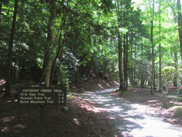
Anthony Creek Trailhead at the Cades Cove picnic area
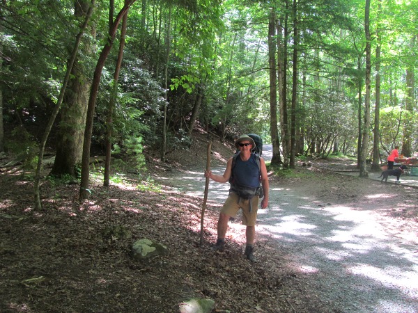
Obligatory self timer shot at the Anthony Creek Trailhead
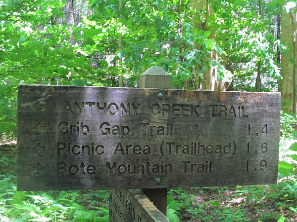
Anthony Creek Trail – 1.9 miles to Bote Mountain trail – total 3.5 miles
At the junction with the Russell Field Trail, there are two options for climbing up to the Appalachian Trail. Either the Russell Field Trail or the Bote Mountain Trail. I was staying at Russell Field, but I wanted to see Spence Field and hike a little longer, so I continued on Anthony Creek to the Bote Mountain Trail. I could not stay at the Spence Field shelter as it was closed due to bear activity.
Anthony Creek Trail – Great Smoky Mountain trail signage
Great Smoky Mountain trail sign – Anthony Creek Trail
Bote Mountain Trail – 1.7 miles – total 5.2 miles
This trail takes you to Spence Field on the AT. Every trail that summits to the AT in the Smokies is a son of a bitch, and Bote Mountain is no different. It went up and up and up till I was sweating, cursing, and wishing I was anywhere else than here. Soon I saw blue sky at the horizon of the trail as if I was heading towards the end of the world to find a sign for the Appalachian Trail. Despite the difficulties, it is a great feeling to finally summit and make it on America’s most iconic trail.
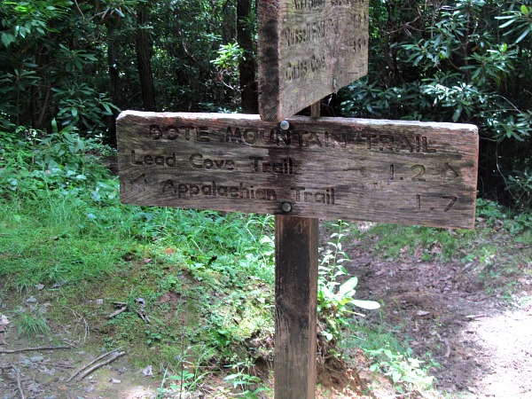
Great Smoky Mountain trail sign – Bote Mountain
Appalachian Trail – Spence Field to Russell Field – 3.1 miles – 8.3 total
I was hiking the AT from north to south here and this stretch was almost all downhill. For thru hikers heading to Maine, this would mean this trail is all up. Spence Field is approximately 5,070 while Russell Field is around 4,700 feet. Spence Field shelter is currently closed due to an aggressive bear, so I stayed at Russell Field.
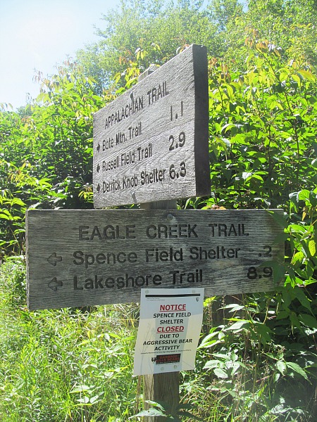
The iconic Appalachian Trail – Note the sign for bear closure
The famous white blaze on the Appalachian Trail
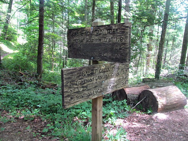
Day 2 – Appalachian Trail – Russell Field to Mollie’s Ridge – 3.3 miles (sign incorrectly states 2.5) trip total 11.6
The section from Russell Field to Mollie’s Ridge is a gradual up and down. You climb a few knobs (small little peaks on the ridge) and then you descend down. The sign at Russell Field shows 2.5 miles to Mollie’s Ridge shelter, but when you get to Mollie’s Ridge the sign there says 3.3 miles to Russell Field. I believe the latter sign as it was farther than 2.5 miles. The signs are not always 100% accurate.

Great Smoky Mountain trail sign to Mollie’s Ridge Shelter

Great Smoky Mountain trail sign conflict – Is it 2.5 or 3.3?
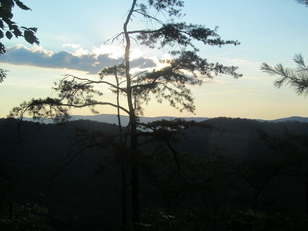
Day 2 – Appalachian Trail – Mollie’s Ridge to Gregory Bald 3.1 miles – Day total 6.4 – Trip total – 14.7
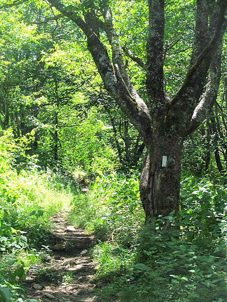
More of the same along the Appalachian Trail to Gregory Bald Trail. There are no views off the Appalachian Trail during this stretch. The trail is sometimes called the long green tunnel due to its lack of views and abundance of trees that grow at the top of the AT ridge.

Why the Appalachian Trail is sometimes referred to as the long green tunnel
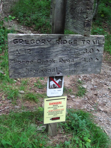
Gregory Bald Trail to Gregory Ridge Trail – 2.0 miles – Day 2 total 8.4 – Trip total 16.7
I left the AT for the Gregory Bald Trail. I was heading for my next reservation, which was campground 14 along the Hannah Mountain Trail.
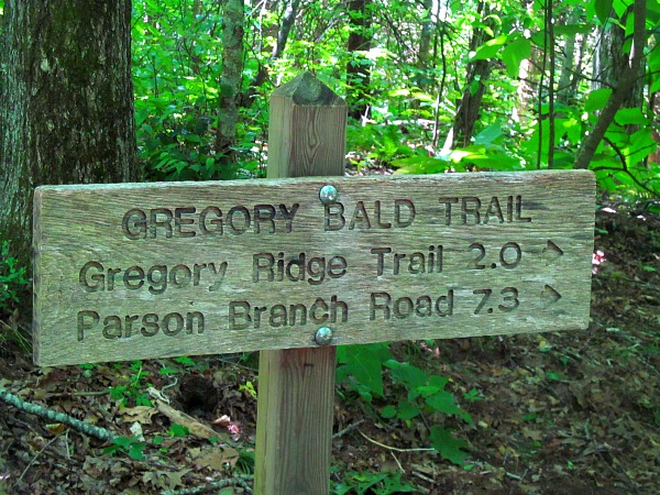
Gregory Bald Trail
Gregory Ridge Trail to Forge Creek Road – 4.9 miles – Day 2 total 13.3 – Trip total 21.6
Unfortunately, Gregory Bald Trail was closed due to aggressive bear activity, so I had to walk down to a road and take a road to outflank the closed trail and the bear. This was listed on the national park website, but I failed to notice that my hike would be impacted by the closure. I saw the Gregory Bald campground was closed, but I did not see the trail was likewise closed. A good tip is to carefully read these warning as this inconvenience lead to a 20 mile hike instead of an already exhausting 16 mile hike. I did not get into the campsite until 7 p.m.
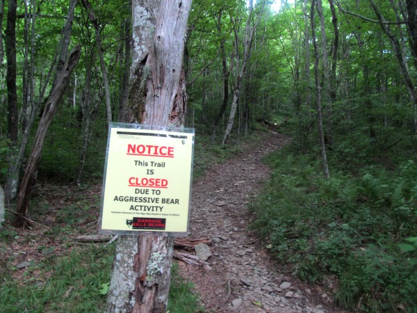
Sorry folks, trail is closed
Plan B is to outflank the aggressive bear via the Gregory Ridge Trail
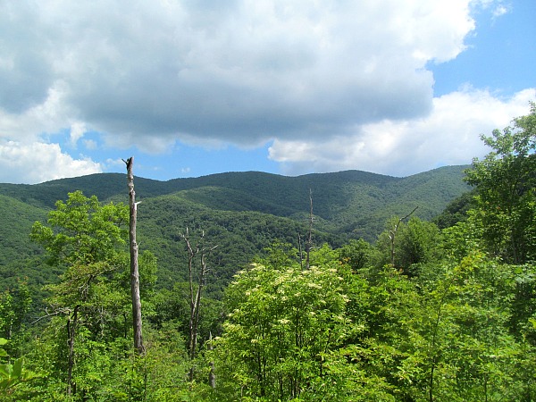
Finally got a few nice views on the Gregory Ridge Trail of the mountains
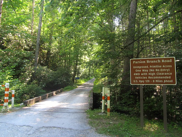
Parsons Branch Road to Hannah Mountain Trail – 3.0 miles Day 2 total 16.3 – Trip total 24.6
I reached the parking lot for the Parsons Branch road and soaked my sore feet in the mountain stream and then headed up the road for three miles. It was nice walking on soft gravel, but I would prefer working on a trail through the woods. The road was more up than down, but the incline was not too torturous.
Up the Parsons Branch Road
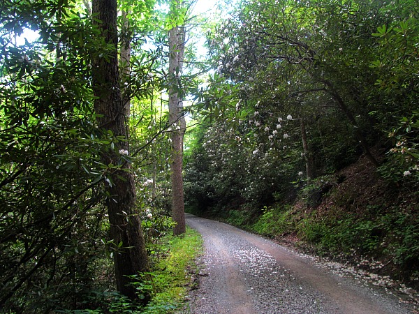
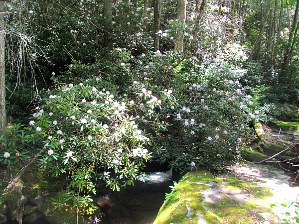
Rhododendrons in full bloom along the Parsons Branch Road
Hannah Mountain Trail to Rabbit Creek – 7.6 miles – Day 2 total 20.3 (stopped at campground 14) – Trip total 32.2
I had about four more miles to my camp. A 20 mile day is something many thru hikers take weeks to acclimate to, but here I was doing it on my second day of a short three day hike. My body was numb except for my shoulders and feet that unfortunately always felt sore and never numb. On the bright side, once I came off the AT, I mainly was hiking downhill or on level ridge trails.
Great Smoky Mountain trail from Hannah Mountain to Rabbit Creek
Twilight time as I approach a 20 mile day on the Hannah Mountain Trail
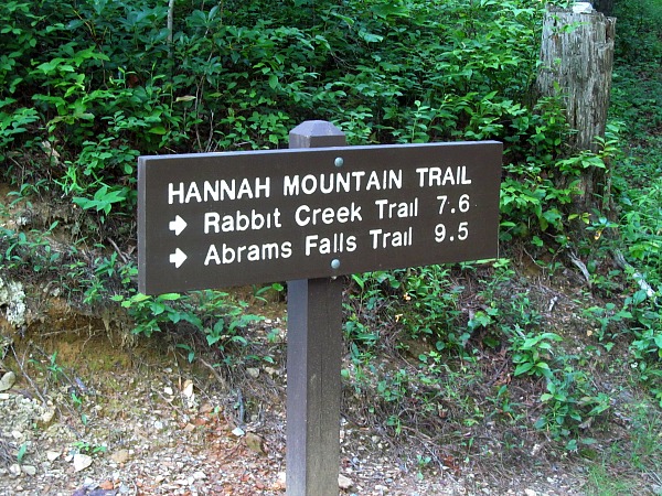
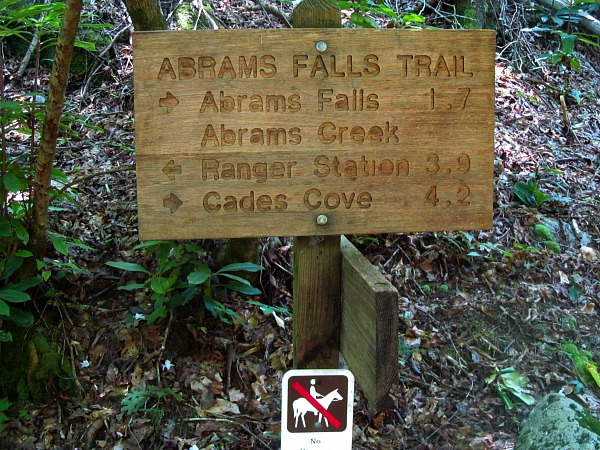
Rabbit Mountain Trail to Abrams Falls Trail – 1.9 miles – Day 3 total 5.5 – Trip total 34.1
Sometimes the signs do not put on what is important to you. I was hiking on the Rabbit Mountain Trail to Abram’s Creek, but this sign did not find the Abrams Falls Trail junction worthy enough to put on the sign. The Hatcher Mountain Trail went the opposite direction at about the same point as the Abrams Falls trail, so I knew which was to go after consulting the map.
Great Smoky Mountain trail towards the Hatcher Mountain Trail
Abrams Falls Trail to Cades Cove-4.2 miles – Day 3 total – 9.7 – Trip total 38.3
In the backcountry ever since leaving the AT for the Gregory Ridge Trail I had not seen anyone except for cars along the Parsons Branch Road. All of a sudden, I came upon the masses on a pilgrimage to Abrams Falls from Cades Cove. It is a beautiful waterfall, and I cannot blame them. I took a dip in the cool pool below the falls that felt heavenly.
Great Smoky Mountain trail sign for Abrams falls Trail
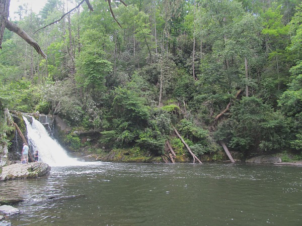
Abrams Falls and a beautiful pool for swimming
Abrams Falls parking area to Cades Cove Campground – 2 miles until picked up – Day 3 total 11.7 – Trip total 40.3
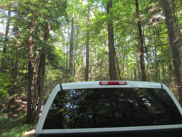
My car was parked at the Cades Cove Campground, which was 7 miles away from where I emerged at Abrams Falls. I figured it would be a nice hike through Cades Cove. There is not a convenient loop for this section of the AT from Cades Cove. After a 20 mile day and then another 10 this morning, I was ready for the trip to end. Perhaps I was inspired by Expert Vagabond’s hitchhiking adventure across the U.S. If he could hitchhike the whole country, I sure could get a ride for 7 miles back to my car.
After a two mile walk, success was achieved
I hiked up the Cades Cove scenic loop road and stuck out my thumb until I heard the magical words “do you need a ride?” I turned to see a beautiful white pickup truck. I jumped in the back and thoroughly enjoyed motoring in style as the wind cooled my hot body down. I looked at the beautiful mountains that I just came down from and looked forward to exploring them again.
Adventure on!
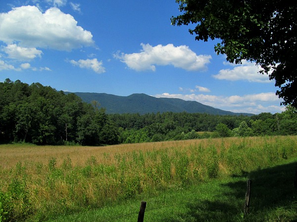
Wonderful views of Cades Cove from the back of the pickup truck that I hitched a ride from

The goal of Traveling Ted is to inspire people to outdoor adventure travel and then provide tips on where and how to go. If you liked this post then enter your email in the box to get email notifications for each new entry. Daily travel photos are excluded from your email in order to not flood you with posts. There is no spam and email information will not be shared. Other e-follow options include Facebook (click on the like box to the right) or twitter (click on the pretty bird on the rainbow above). On the right sidebar is a donate button. If you would like to donate in order to support the site, it would be appreciated. All donations would cover travel expenses and improvements to make the site better.

Is that much “aggressive bear” activity common in the park? And do you have any desire to ever thru-hike the AT? Twenty miles in one day, NOT on a thru-hike, is pretty badass, Tedward.
I am not sure Francesca. I have never seen them have so many closures, but I usually come in the fall and apparently they are more active in the summer. I could not believe how many bears I saw on this trip. I would love to thru hike the AT someday.
wooow! Nice photos! I invite you to Cavehill in Belfast
Thanks Damian. I might have to take you up on that offer someday.
I haven’t been to the Smokies since I was a kid, and have never hiked it. I’m not as adventurous as you, so I don’t really have a desire to hike the AT. But I would love to hike parts of it. I really need to get back to the Smokies. I like the idea of fall if there are fewer bears. Obviously a lot more people with the beautiful colors.
The bears are always there it just seems they are more active in the summer. I have never seen a bear on many hikes in the fall. There are always a lot of people in the Smokies, but the park is so big, it is easy to beat the crowds especially if you hike a few miles. I was here on 4th of July and the campgrounds were packed, but I hardly saw anyone in the backcountry trails (backcountry meaning any trail besides the AT) and even the AT was lightly traveled (except by bears).
The rhododendrons looked gorgeous.
My brother is an AT segment hiker. He has done portions of the AT in all 14 states it passes through. I have done about 100 yards of the AT in Virginia near Roanoke. (He is the hiker, I am the biker.)
I have only done the AT through the Smokies. Never stepped foot on it in any other state, although the AT through the Smokies is the border of Tennessee and North Carolina, so I have been in only 2.
Good thing those aggressive bears didn’t see you in that sleeveless shirt. 😉
Yes, this shirt is called an aggressive-ometer. It brings out the aggressive ones who see me in that shirt and can’t help themselves.
Aggressive bear activity!? NO THANK YOU! I did not like that sign.
You’re photos, on the other hand, are beautiful. Since I’ve started hiking, I’ve heard great things about the Smoky Mountains. As usual, your post just makes me want to get there sooner than I had planned! 🙂