


Hiking Timm’s Hill – The entrance to the observation tower
Hiking Timm’s Hill is more convenient than Everest
For those who do not have a cool $40,000 on a guided trip to climb Mt. Everest, but like to accomplish challenges, try hiking Timm’s Hill in Wisconsin instead. At 1,951.5 feet it is the highest point in Wisconsin. There is no need for a Sherpa, although if you can arrange one so much the better, no need for oxygen, and no dangerous ice crevasses to watch out for.
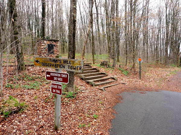
The biggest challenge to hiking Timm’s Hill is finding the parking lot. If you have a Rand McNally Road Map it will help as there is a little red mark where the highest point is located on the map. The closest main road to the park is State Route 86, which meets up with Highway 51 in the town of Tomahawk. Unfortunately, there is no sign off of 86 for the park.
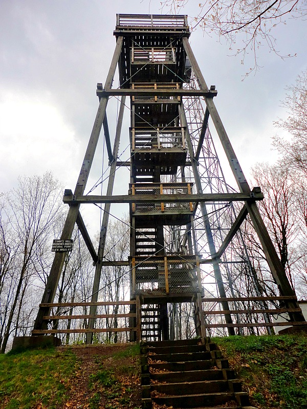
Timm’s Hill Observation tower
Getting to Timm’s Hill County Park
You need to turn south on Country road RR at the sign for High Point Village. You will then eventually find a one way road leading you into the County Park and to the Timm’s Hill observation tower.
I usually leave the directions to a location for last, but I found it so difficult to find it that I wanted to provide readers with a guide to get there first. Once the location is found it is smooth sailing from here.
Parking lot for Timm’s Hill observation tower
Beginning the Timm’s Hill ascent
After getting out of the car, there was a sign for Timm’s Hill stating it was 300 yards away. Despite being over 1,800 feet, I was able to breathe without any difficulties. I proceeded with my climb of Timm’s Hill without a Sherpa and without oxygen. I scanned the sky for any dark clouds. I did not want to get caught on top of the tower in a rogue storm. It was a warm day, but on top of the highest point in Wisconsin in April, a freak snow storm is not out of the question.
I proceeded up the trail. I did not want to dilly dally, but I did not want to exert too much effort in the thin atmosphere as I crossed the 1,900 foot threshold. Soon, I made the tower and before I reached the very top there was a sign stating the elevation. After taking a picture I made that last step to the apex. Timm’s Hill is 1,951.5 feet and the last .5 feet were the toughest.
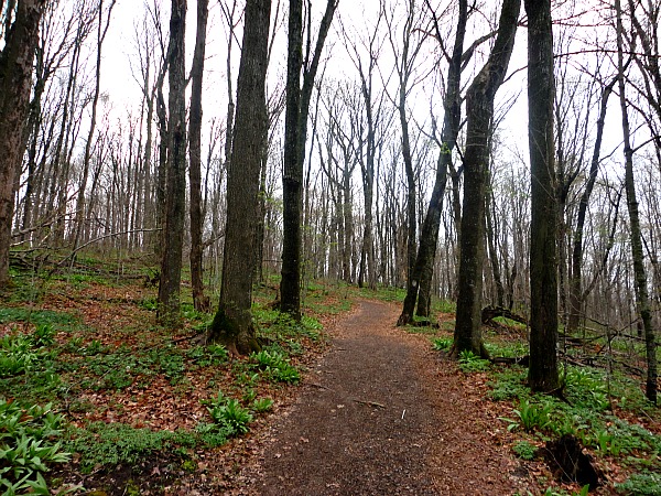
Hiking Timm’s Hill – The start of the trail
The Timm’s Hill summit
I had climbed to the Timm’s Hill pinnacle, but the adventure was not over. It was now time to ascend the stairs to the top of the observation tower. I proceeded, and I was soon above the tree line. The observation tower steps were steep and without a Sherpa my camera and water bottle weighed on me, but I was able to master the last flight of steps, and I was on top of the world – or at least the world known as Wisconsin.
The reward for Hiking Timm’s Hill
It was amazing to know that I was higher in Wisconsin than all cheesehead hats, Aaron Rodgers, anyone drinking a Leinenkugel beer in the state, any badger, Scott Walker, the House on the Rock, every cow in the state, and every deer hunter in the state. I felt extremely powerful.

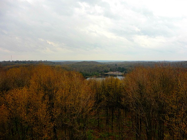
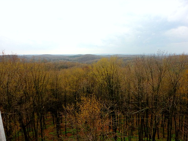
More views from the observation tower after hiking Timm’s Hill
Besides the adrenaline rush and ego boost, the view was very beautiful as well. Glaciated hills rolled smoothly in the distance, the hills were thick with trees in the Wisconsin Northwoods, and the overlook peered over two local lakes.
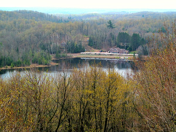
Close up of the lake at High Point Village from Timm’s Hill
I hiked down from the platform, down the stairs, and down the trail to my car. I got in the car and resumed my normal life at the same elevation as the rest of the state. I will not forget my moment in the clouds when I hovered over the rest of America’s Dairyland and the fact that I did it unaided by oxygen and Sherpa.
One last view from Timm’s Hill
For those looking for a longer hike, consider hiking the Timm’s Hill Trail, which is a ten mile trail that links the highest point with the Ice Age Trail.
Adventure on!

The goal of Traveling Ted is to inspire people to outdoor adventure travel and then provide tips on where and how to go. If you liked this post then enter your email in the box to get email notifications for each new entry. Daily travel photos are excluded from your email in order to not flood you with posts. There is no spam and email information will not be shared. Other e-follow options include Facebook (click on the like box to the right) or twitter (click on the pretty bird on the rainbow above).
On the right sidebar is a donate button. If you would like to donate in order to support the site, it would be appreciated. All donations would cover travel expenses and improvements to make the site better.

Important to remember not to fly in an airplane on the same day as climbing Timm’s Hill, as it might cause yer head to explode! You don’t want want that, now, eh?